 Antigua Guatemala City Guide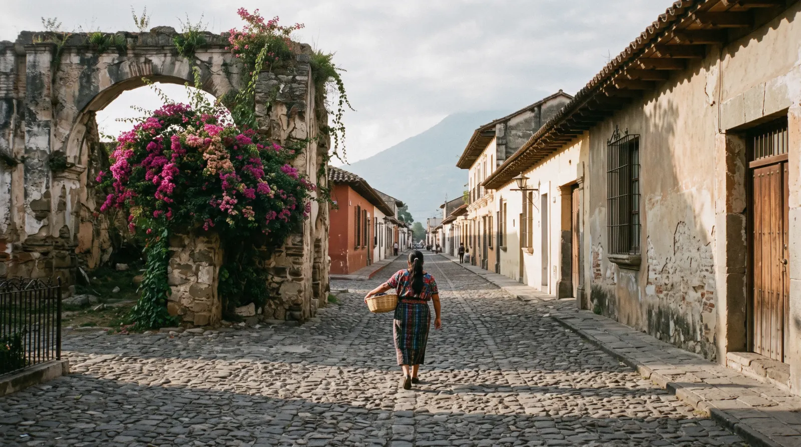
Walks in Antigua: Four Self-Guided Routes
Walks in Antigua are the easiest way to understand this city, because the colonial grid is flat, compact and built for pedestrians. This guide gives you four self-guided routes, from the arch corridor to the hilltop cross above town, and tells you what each one costs and passes. For the wider picture start with our things to do overview and the plan hub, then pick a route below. The routes are one layer of the Antigua Guatemala city guide, whose homepage carries the rest of the plan.
Quick answer How walkable the grid is, the one climb, and the cheap way out
Yes. The colonial core sits on a flat grid of cobblestone blocks roughly eight by eight, and almost everything a visitor wants is inside it. INGUAT, the national tourism institute, describes even the one real climb, the signposted trail to Cerro de la Cruz, as a 20 to 30 minute walk from the historic centre. When legs give out, the municipal tuk-tuk tariff is Q10 ($1.31) per ride within the city.
Key takeaways
- The grid is flat and compact. Our three central routes each stay within a handful of blocks of Parque Central, and none needs transport.
- Only one route climbs. Cerro de la Cruz is a city hill viewpoint with a signposted trail that INGUAT says takes about 20 to 30 minutes from the historic centre.
- The escape hatch is cheap. The municipality set the in-city tuk-tuk fare at Q10 ($1.31), and drivers usually stop working around 22:00. See getting around.
- If you would rather have someone narrate, the guided walking tour covers the same central ground with a guide.
The four walks at a glance
All four routes start and finish inside or beside the flat colonial grid, so times are our estimates for an unhurried walker who stops for photos, not official figures. Every route costs nothing on foot, and the tuk-tuk fare of Q10 ($1.31) applies if you want a lift back.
| Route | Time (our estimate) | Cost | What you pass |
|---|---|---|---|
| Walk 1: The arch corridor and La Merced | 45 to 60 minutes (our estimate) | Free on foot | Parque Central, the Santa Catalina Arch, 5a Avenida Norte, La Merced |
| Walk 2: Churches and convents | 1.5 to 2 hours (our estimate) | Free on foot, paid entry at Capuchinas | Cathedral block, San Francisco, Capuchinas |
| Walk 3: Market, terminal and the working city | 1 to 1.5 hours (our estimate) | Free on foot, Q15 ($1.96) if you ride the Guatemala City bus | El Mercado, the chicken-bus terminal, market-edge streets |
| Walk 4: Up to Cerro de la Cruz | 20 to 30 minutes up, per INGUAT | No official fee | Signposted hill trail, cross platform with the full grid under Volcán de Agua |
Times for walks 1 to 3 are our estimates on the flat grid. The Cerro de la Cruz figure is INGUAT's published trail time. Fares checked against municipal and operator sources, current in Q3 2026.
How the grid works under your feet
Every route below is easier once the street logic clicks, because Antigua's grid is one of the simplest colonial layouts in the Americas.
The city is a rectangle of numbered avenidas running north to south and numbered calles running east to west, all anchored on the park, which the records also call Plaza Mayor, Plaza Real and Plaza de Armas. Avenidas gain numbers as you move away from them in either direction, calles as you move away in theirs, so an address with a low number sits within a few blocks of the centre. Orientation is by volcano: Agua closes the southern horizon in a straight line behind the arch, so if the volcano is behind you, you are walking north.
Two street names carry their own history. 5a Avenida Norte between the park and La Merced is popularly the Calle del Arco, after the convent bridge that has spanned it since the 1693 construction began. And the Calle de los Pasos beside the cathedral takes its name from the station-of-the-cross processions that still move through it in Lent. When a route in this guide says "head north under the arch", it means walking away from the volcano, uphill almost imperceptibly, toward the cross on the hill.
Walk 1: The arch corridor and La Merced
Start at Parque Central and head north under the arch
Begin on the benches of Parque Central, the square once known as Plaza Mayor and Plaza de Armas. The Fuente de las Sirenas at its centre was built by Diego de Porres in 1737, and the long baroque facade on the south side is the Palacio de los Capitanes, whose construction began in 1558 and which today houses INGUAT offices and the National Police headquarters. From the park, walk north up 5a Avenida Norte.
In our estimate this stretch takes about five minutes at a stroll, and it is the most photographed block in the city, the corridor INGUAT and travel writers treat as the city's defining pedestrian landmark street. Read the full story of the structure in our Santa Catalina Arch guide.
The arch itself
The Santa Catalina Arch was begun in July 1693 so that cloistered nuns of the Convento de Santa Catalina could cross the street unseen between their buildings. It technically functions as a bridge, 23 metres long, and it spans the street in baroque style as part of the UNESCO World Heritage Site declared in 1979. The clock in the small tower was not part of the original design.
It was installed in the 1890s under General Manuel Lisandro Barillas, is a French Lamy Amp Lacroix mechanism, and must be wound every three days. Note that sources conflict on that clock date, so treat the century rather than the exact decade as the firm part of the story. The arch was restored in 2017 and belongs to the municipality, while the former convent beside it is now a private hotel.
Finish at La Merced
Continue north a few more blocks, about five to seven minutes in our estimate, and the yellow and white facade of La Merced closes the street ahead of you. Construction began in 1749 under architect Juan de Dios Estrada and the church was dedicated in 1767, which is why it survived the 1773 Santa Marta earthquakes practically new and stayed open for worship while the rest of the city fell. Its Guatemalan Churrigueresque facade carries two bell towers and St. Peter Nolasco above the entrance.
In the convent courtyard behind the church sits the Fountain of los Pescados, 27 metres in diameter and among the largest colonial fountains in Latin America. This is also the origin point of two major Holy Week processions, the Palm Sunday and Good Friday Procession of Penance, so if you walk it in the weeks before Easter expect carpets on the cobbles. Our La Merced page has the detail.
Walk 2: Churches and convents
The cathedral block, ruin and parish in one
Start again from the south side of Parque Central, where the cathedral block occupies the whole eastern edge. The first construction began in 1545. A second sanctuary was inaugurated in 1680 and the church was elevated to a Metropolitan cathedral in 1743.
Then the Santa Marta earthquakes of 1773 seriously damaged the structure, the capital moved away within a few years, and the building never recovered its rank. In 1804 the parish of El Señor San José was created inside the rebuilt section, and that parish still holds services today while the rest of the fabric stands open to the sky. Later quakes in 1874 and 1976 cost the parish its bell towers and damaged the facade.
Pedro de Alvarado's remains were reinterred here in December 2007. Our cathedral page covers visiting. Entry prices and hours for the ruined sections are not published by any official source, so check on site.
South to San Francisco
Walk about eight minutes south and east in our estimate and you reach San Francisco, one of the largest church complexes in the city. After an earlier chapel was damaged in 1565, a new sanctuary was built in 1579 and some 16th-century fabric survives. The current church, the one you see, was built by Diego de Porres and inaugurated in 1702, in Spanish seismic baroque with Salomonic columns.
It has been damaged in 1717, 1751, 1773, 1917 and 1976, and part of the ruin was left unrebuilt until 1967. The reason pilgrims come is inside: Santo Hermano Pedro, beatified in 1980 and canonized in 2002, is enshrined here, and his tomb draws thousands of pilgrims every year. A film footnote too, the ruins served as the temple set in The New Adventures of Tarzan in 1935, and Eadweard Muybridge photographed them in 1875.
Back north to Capuchinas
From San Francisco it is roughly ten minutes north in our estimate to Convento de las Capuchinas on the corner near the arch. King Felipe V approved the convent in 1725, construction started in 1731 under its original name of Convento e Iglesia de Nuestra Señora del Pilar de Zaragoza, and the church was consecrated in 1736, making it the last convent built in the city. It was damaged in 1751 and abandoned after the 1773 quakes by order of the Captain General.
Its most curious feature survives: cells built in a circle around a central common chamber, with underground passages, described by Prince Wilhelm of Sweden in 1920. The site is owned by the CNPAG and access is paid, but no official tariff is published online, so expect to buy a ticket at the gate and confirm the amount there. This is the only paid stop on any of the four routes, and the entry fee is worth it for the circular courtyard alone.
Walk 3: Market, terminal and the working city
West out of the grid to El Mercado and the terminal
This walk leaves the postcard streets and crosses into the city most residents use. From Parque Central walk west along 4a Calle Poniente, about fifteen minutes in our estimate, to El Mercado, the municipal market, with the chicken-bus terminal in the lot behind it on the north-west side of the 4a Calle Poniente and Alameda Santa Lucía intersection. INGUAT refers generically to artisan markets in the city, but the municipal market itself has no official published hours or hall-by-hall map, so what you find is what is trading that day.
Buses to Guatemala City leave from the street south of the artisan market, honking from around 05:30 and departing every few minutes. Our mercado and chicken buses pages carry the practical detail.
The bus fare and the official safety picture
If you want to ride rather than just watch, the sourced fare for the Guatemala City chicken bus is Q15 ($1.96), cash only, picking up at El Trebol in the capital and dropping near the market in Antigua. But read the official guidance before you board. The UK Foreign, Commonwealth and Development Office advises: "Avoid travelling on public buses (repainted US school buses).
There have been incidents of attacks and extortion by local gangs on bus drivers.. These buses are usually poorly maintained, overcrowded and do not generally adhere to the rules of the road.. Accidents are common and sometimes fatal.
Private intercity coach services are generally safer, but gangs have also targeted these." The FCDO also notes there have been armed attacks or robberies on most tourist routes between Guatemala City, Antigua, Tikal, Petén and Lake Atitlán. For that reason we treat this walk as a look at the terminal from the market edge rather than a recommendation to ride the public buses, and we point travellers to private shuttles instead. Walk back through the market edge and the grid streets east, about fifteen minutes in our estimate, and you are back at the park.
Walk 4: Up to Cerro de la Cruz
The signposted trail INGUAT describes
Cerro de la Cruz is the hill on the city's north-east edge, crowned by a large white cross, and it is the only one of these walks that leaves the flat grid. INGUAT's official Antigua page calls it the viewpoint with the most iconic views of the city and says the trail is signposted, taking about 20 to 30 minutes from the historic centre. That is the only trail figure any official source publishes, so our own route guidance starts at the north end of 1a Avenida Norte and follows the signs uphill from there.
Our Cerro de la Cruz page collects everything that is and is not confirmed.
What the cross platform gives you
The payoff is the whole colonial grid laid out below you with Volcán de Agua rising directly behind it. Every route in this guide makes sense from up there: the straight line of 5a Avenida Norte, the bulk of the cathedral, the towers of La Merced. It is the photograph of Antigua, and it is the reason INGUAT calls these the most iconic views.
Go in the morning, both for the clearest light on Agua and to avoid the afternoon rain that settles in during the wet months. We consider this a city hill viewpoint, an easy half-hour climb, and nothing more ambitious than that.
The honest negatives
No official fee, opening hours or shuttle service for Cerro de la Cruz is published anywhere citable. We searched the municipal site, INGUAT and local sources and found none, and we will not invent one. A shuttle service has been reported informally by travellers, but it has no official trace and we cannot confirm it exists on any given day, so plan to walk.
That also means no official statement on security staffing at the viewpoint. Our practice is to do this walk in daylight, in the morning, and to skip it entirely if the trailhead feels wrong on the day. Nothing in any official source contradicts that caution, and nothing confirms comforts that are not there.
Extending the hill day
If the climb lands before noon, the natural extension is walk 1 in reverse: down the hill, north up 5a Avenida Norte with lunch at the crêperie on 6a Avenida Norte, which opens Sunday to Thursday 10:00–21:00 and Friday to Saturday 10:00–22:00 and takes no reservations. That turns the shortest route into a half-day loop with one climb, one corridor and one long lunch, and it ends within two blocks of where it started. If the legs vote otherwise, the municipal Q10 ($1.31) tuk-tuk tariff applies to the ride home like anywhere else in the grid.
Walking Antigua: the practical layer
Cobbles, altitude and the morning window
The cobbles are the first thing your ankles will tell you about. The whole grid is paved in uneven stone, polished smooth in places, and we recommend closed shoes with real soles rather than sandals for any of these routes. The city sits at roughly 1,530 metres, about 5,013 feet, which most visitors feel as stronger sun and a mild day temperature rather than real breathlessness on the flat.
Days run warm to mild year-round while nights drop into the low teens Celsius, so a layer helps for evening walks. The one hard rule is timing. The rainy season runs from May to October, and September is the wettest month at 311 mm with around 28 rainy days, most of it arriving in the afternoon.
Morning is the walking window all year, and the dry season from November to April gives you the most reliable full days. Our weather page has the month-by-month table.
Tuk-tuks, fares and walking at night
The municipality set the official moto-taxi fare at Q10 ($1.31) per ride within the city. In practice drivers commonly ask visitors Q15 ($1.96) or more, tuk-tuks are not metered, they take cash, and they generally stop working around 22:00, so negotiate the fare before you get in. On night walking, we frame this as our practice rather than an official statistic: we walk the central grid streets in the evening when restaurants and lit shopfronts keep them lively, we take a tuk-tuk rather than walk to the market and terminal edges after dark, and we avoid the Cerro de la Cruz trail at night entirely.
The FCDO advises getting up-to-date security information from INGUAT, and INGUAT's ASISTUR programme provides tourist police in locations frequented by tourists such as Antigua, reachable on 1500 or +502 2290-2810 around the clock.
Situations and what we do
The table below collects the judgment calls in one place. None of it is official rule, it is how we walk the city.
| Situation | What we do |
|---|---|
| Cobblestones slowing you down or hurting your ankles | Wear closed shoes with thick soles and shorten the route rather than rush it |
| Afternoon rain clouds building, May to October | Do the outdoor walking in the morning and keep the ruins and viewpoints for the driest hours |
| Legs tired or running late | Take a tuk-tuk, agree Q10 ($1.31) before boarding and expect to be asked Q15 ($1.96) |
| After about 22:00 | Walk only the busiest central streets or take a tuk-tuk before the drivers wind down |
| Heading up Cerro de la Cruz | Morning, daylight, and skip it if the trail feels off |
| Rain all day | Switch to indoor options such as the Chocomuseo workshops, daily 10am to 7pm, or the museums listed in our rainy-day guide |
A walking day, assembled
The four routes are modular, and this is the order we would stack them into one day, with our own minute estimates and the tuk-tuk hatchbacks marked.
Take the morning light up the hill first, because Cerro de la Cruz rewards clean air and costs only 20 to 30 minutes of climbing by INGUAT's measure. Come down for coffee on the park, then run walk 1 north through the arch corridor to La Merced while the facades are still front-lit, about 45 to 60 minutes at photo pace. Lunch near the park, then walk 2 south through the cathedral block and San Francisco to Capuchinas in the early afternoon, when the convent walls hold shade.
Allow 1.5 to 2 hours with the paid stop. Save walk 3 for the late afternoon market build-up, an hour to an hour and a half, and tuk-tuk home from the terminal edge for the municipal Q10 ($1.31) rather than retracing the whole route on foot.
- Morning: the hill, 20–30 minutes up, clearest air of the day
- Late morning: walk 1, the arch corridor and La Merced, 45–60 minutes
- Early afternoon: walk 2, churches and convents, 1.5–2 hours with the Capuchinas stop
- Late afternoon: walk 3, the market and terminal edge, 1–1.5 hours, tuk-tuk back
In the wet months, swap the order rather than the plan: the hill and walk 1 still belong to the morning, and walk 2's convents and churches are the natural rain-delay fallback, because most of their interest is under roof. If the day is a total washout, the indoor alternatives live on our rainy day guide instead.
Dos and don'ts for walks in Antigua
Do
- Start walking before mid-morning so you finish the outdoor stretches before the afternoon rain in the wet months.
- Wear closed shoes with grippy soles, because every street in the grid is cobblestone.
- Agree the tuk-tuk fare before you get in, quoting the municipal Q10 ($1.31) rate.
- Carry small cash notes for tuk-tuks, market stalls and bus fares, since cards are not normal there.
- Climb to Cerro de la Cruz in the morning for the clearest view of the grid under Volcán de Agua.
Don't
- Don't plan to ride the public chicken buses as part of a leisure walk, the FCDO advises avoiding them.
- Don't count on an official shuttle or ticket office at Cerro de la Cruz, because none is published.
- Don't attempt the hill trail after dark, there is no official lighting or staffing information for it.
- Don't rely on tuk-tuks late at night, they generally stop working around 22:00.
- Don't assume published entry fees for the cathedral ruins or Capuchinas, no official tariff exists online so confirm at the gate.
When to take a guided walking tour instead
Two guided options, priced as listed
Self-guiding costs nothing and moves at your pace, but a guide earns their fee when you want the history told rather than read, when your time in the city is short, or when you would rather not navigate the first day. Two guided options are priced as listed: the classic central walking tour at $25, which covers the Parque Central, the arch corridor and the historic core that walks 1 and 2 trace, and the extended guided option, also $25, which pushes further into the same territory with commentary throughout. Both are the logical alternative to the routes above, and both leave the hill climb to you, since no operator runs an official Cerro de la Cruz service we can verify.
How to choose
Take the guided walking tour on your first morning if you want orientation and stories, then repeat walk 1 or 2 on your own at photo pace. Take the second option if you have a single day in the city and want the maximum covered in one booking. If your interest is the market and the terminal, no guided option replaces walk 3, because that route is about watching a working city rather than hearing dates.
And if you are here for the views, the Cerro de la Cruz climb remains a do-it-yourself affair.
The four walks on one map
Every pin is a stop on one of the four routes, plotted from recorded coordinates, so you can see how much of the city the walks cover on foot.
Where the walking continues
These are the pages that extend each route beyond this guide, with the walk minutes as our estimates.
Santa Catalina Arch
The 1693 bridge, its clock and its restoration, on the arch page.
3 min from the parkLa Merced
The 1767 survivor of 1773 and its 27-meter fountain, on the La Merced page.
8 min from the parkCerro de la Cruz
The climb, the cross and what no official source confirms, on the Cerro page.
20–30 min up, per INGUATRainy day Antigua
When the sky closes the routes, the indoor plan takes over on the rainy day page.
The wet-hour planWalks in Antigua: questions
Is Antigua Guatemala walkable?
Yes. The colonial core is a flat, compact grid and the three central routes in this guide need no transport at all. Even the one climb, the signposted Cerro de la Cruz trail, takes about 20 to 30 minutes from the historic centre according to INGUAT. Our things to do overview lists what fits around the walks.
Can you walk everywhere in Antigua?
Inside the colonial grid, essentially yes. The market and the chicken-bus terminal are a longer walk of roughly fifteen minutes in our estimate, and places like Hobbitenango outside town are not walkable destinations from the centre, so for those you need transport. See getting around for tuk-tuks and shuttles.
How long does it take to walk up Cerro de la Cruz?
INGUAT's official page says the signposted trail takes about 20 to 30 minutes from the historic centre. There is no official fee, opening hours or confirmed shuttle, so plan on foot and in daylight. Full detail on our Cerro de la Cruz page.
Is it safe to walk at night in Antigua?
No official statistic covers night walking in the city, so we frame it as our practice. We stay on the busiest central grid streets in the evening, take a tuk-tuk for the market and terminal edges after dark, and avoid the hill trail at night. Tuk-tuks generally stop working around 22:00. INGUAT's ASISTUR tourist assistance line is 1500 or +502 2290-2810 around the clock, and more transport context is on our chicken buses page.
Which streets are the best for a walk in Antigua?
5a Avenida Norte between Parque Central and La Merced is the classic, running under the Santa Catalina Arch on the corridor described as the city's most recognizable pedestrian landmark street. 4a Calle Oriente past the cathedral and the arch-side blocks around Nim Po't are the other favourites. Walk 1 in this guide strings them together, and the arch page has its history.
What is the cheapest way to get around if I get tired walking?
A tuk-tuk. The municipal tariff is Q10 ($1.31) per ride within the city, though drivers often ask visitors Q15 ($1.96), so agree the fare before boarding. They take cash, are not metered, and stop around 22:00. The full picture is in getting around.
Prices, hours and terms are set by the venue or operator and confirmed at checkout.
We may earn a commission if you book through one of our links, at no extra cost to you. Full affiliate disclosure